Sentinel-3C has sent back its first views of Earth, giving scientists an early look at how the newest Copernicus ocean-and-land monitoring satellite is performing. The first results include natural-colour scenes of Italy, the Canadian Arctic and the Caribbean, plus early altimeter measurements over the sea surface and Greenland ice sheet. Together, these first acquisitions show why the mission matters: it extends a long-running stream of environmental data used to understand oceans, land, ice and the atmosphere.
What did Sentinel-3C see first?
Sentinel-3C first returned imagery and measurements from two key instruments: the Ocean and Land Colour Instrument, known as OLCI, and the Synthetic Aperture Radar Altimeter, known as SRAL. OLCI captured broad, colour-rich views of Earth’s surface, while SRAL produced early measurements related to sea-surface height and ice elevation. These are not just “pretty pictures”; they are early signs that the satellite is moving through commissioning toward operational service.
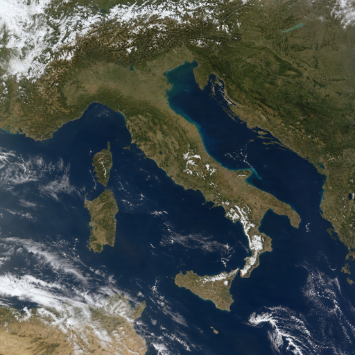
The first widely shared OLCI image, acquired on 30 September 2026, shows Italy in natural colour, stretching from southern Germany and the Alps down through the Italian peninsula to Sicily and the southern Mediterranean. The scene highlights the Po Valley, snow-covered Alpine terrain, the Adriatic Sea, Sardinia, Sicily and coastal colour variations that may be linked to river-borne sediment.
The first views are a performance check, not the finish line
A new Earth observation satellite does not become fully operational the moment it reaches orbit. ESA noted that Sentinel-3C is still in its commissioning phase, a detailed process expected to take several more months, during which teams check the spacecraft, instruments, calibration and data quality. That makes these first views especially important: they provide early confirmation that the satellite is on track while engineers and mission specialists continue the careful work behind the scenes.
The initial set of images is deliberately diverse. Italy offers a complex mix of land, mountains, agricultural areas, islands and coastal waters. The Canadian Arctic scene, also acquired on 30 September 2026, shows snow- and ice-covered islands, exposed rock, dark open water and fractured sea ice at a time of year when Arctic sea ice is near its seasonal minimum. The Caribbean image, acquired on 29 September 2026, captures Cuba and the Bahamas, with shallow turquoise waters contrasting against deeper blue seas.
These different environments help demonstrate the mission’s range. A single satellite pass can reveal vegetation patterns, coastline conditions, water colour, sea ice, clouds and land cover. When paired with measurements from radar altimetry, that visual record becomes part of a broader data system for tracking environmental change.
A quick timeline for Sentinel 3C
For anyone searching for the Sentinel 3C launch date, the key date is 15 September 2026. Sentinel-3C launched with ESA’s FLEX Earth Explorer satellite aboard a Vega-C rocket from Europe’s Spaceport in French Guiana; the flight lifted off at 03:21 CEST, which was 22:21 local time on 14 September in French Guiana. Sentinel-3C was deployed first, followed by FLEX roughly an hour later.
Here is the short version of the mission milestone sequence:
- 15 September 2026: Sentinel-3C launched on Vega-C from French Guiana with the FLEX satellite.
- 29 September 2026: OLCI acquired a Caribbean scene showing Cuba, the Bahamas and surrounding shallow waters.
- 30 September 2026: OLCI acquired views of Italy and the Canadian Arctic.
- 8 October 2026: ESA and EU Space channels highlighted Sentinel-3C’s first images and measurements publicly.
- Commissioning phase: ESA continues instrument and spacecraft checks before full operational service.
This timeline also helps clear up a common point of confusion: the launch occurred in mid-September 2026, while the first public image milestone followed in early October 2026.
Why does Sentinel-3C matter?
Sentinel-3C matters because it strengthens the continuity of Copernicus environmental monitoring. The Sentinel-3 series is designed to observe Earth’s oceans, land, ice and atmosphere systematically, supporting applications such as ocean forecasting, climate monitoring, environmental management and scientific research. Sentinel-3C is the third satellite in the series and is expected to help maintain the long-term flow of data as earlier satellites age.
Continuity is not a glamorous word, but it is essential in Earth observation. Climate and environmental questions often depend on consistent measurements collected over years, not isolated snapshots. If scientists are tracking sea-level change, vegetation stress, sea-surface temperature or polar ice conditions, interruptions in the data record can make analysis harder. Sentinel-3C helps keep that observing chain intact.
The mission is also practical. Copernicus data supports public authorities, researchers, businesses and services that need reliable information about changing environmental conditions. That can include coastal management, fisheries, aquaculture, wildfire response, water quality monitoring, risk assessment and broader climate services.
The instruments turn colour, heat and height into usable data
Sentinel-3C carries instruments built to measure different aspects of Earth’s surface and atmosphere. OLCI observes ocean and land colour across 21 spectral bands, which helps users interpret water quality, vegetation and land-cover conditions. The Sea and Land Surface Temperature Radiometer, or SLSTR, measures land and sea-surface temperature, while SRAL measures surface height over oceans, ice and inland water bodies.
A helpful way to understand the payload is to connect each instrument with the kind of question it helps answer:
- OLCI: What colour is the ocean or land surface, and what can that reveal about algae, sediment, vegetation or land cover?
- SLSTR: How warm is the sea or land surface, and where might heat, fire or thermal change require attention?
- SRAL: How high is the sea surface, an ice sheet, a lake or a river relative to expected levels?
- MWR and orbit-support systems: What atmospheric and positioning corrections are needed to make height measurements more precise?
The first Sentinel-3C release mainly showcased OLCI and SRAL. ESA also signalled that early observations from the temperature radiometer would follow, which means the full story of the satellite’s commissioning is still unfolding.
From beautiful images to everyday decisions
The appeal of a new satellite image is immediate: the colours, coastlines and cloud patterns are easy to grasp. The deeper value comes when those observations are processed into data products that people can use. Ocean colour can help detect algal blooms or sediment movement. Surface temperature can support fire mapping and heat monitoring. Altimetry can contribute to sea-level analysis and measurements of lakes, rivers, sea ice and land ice.
For coastal communities, that kind of information can support planning around water quality, tourism, fisheries and sea-level risk. For land managers, it can help reveal vegetation stress or fire-related conditions. For climate researchers, repeated global measurements help build the long-term evidence needed to distinguish temporary variation from sustained change.
Sentinel 3C is therefore best understood as part of a system, not as a standalone spacecraft. Its value grows when its data is combined with earlier Sentinel-3 observations, other Copernicus missions, ground measurements and models. The result is a more complete picture of a planet that is constantly moving, warming, cooling, blooming, burning, freezing and thawing.
What happens next?
Next, Sentinel-3C continues commissioning before entering full operational service. During this phase, mission teams keep validating instrument performance, comparing measurements with existing datasets and preparing the satellite to deliver reliable information for Copernicus users. Early images are encouraging, but the real success of the mission will be measured by stable, trusted data over time.
That patience is worth it. A satellite like sentinel-3c is not launched for a single headline; it is launched to keep watch, day after day, across oceans, land, ice and atmosphere. Its first views of Earth are a promising beginning, and they point toward years of practical environmental insight.
Key takeaway
Sentinel-3C’s first Earth views confirm an important milestone for Europe’s Copernicus programme. The satellite launched on 15 September 2026, returned early OLCI and SRAL results within weeks, and is now moving through commissioning toward operational use. For scientists, decision-makers and anyone watching Earth’s changing systems, Sentinel-3C adds continuity, resilience and fresh observing power to a mission that turns orbital measurements into real-world understanding.